

Whenever it rains in Kisumu, flooding almost always occurs. More than 40,000 people have already been evacuated in the county, either in evacuation camps at various schools or staying with family and friends on higher ground.
Floods also expose residents to poverty due to property loss, water-borne diseases, and food insecurity due to crop damage.
Since the start of the rainy season, three people have been hospitalized with Bilharz infection and typhoid fever. Areas usually affected by floods include Korwa Central, Korwa East and Kajuru. Nyalenda B, Kisumu Central, Muhoroni sub-county Ombey Ward, Kisumu West South West Central Ward and Kadibo are also vulnerable to flooding.


So why does this lakeside region continue to flood? Several factors contribute to this.
terrain
Kisumu's topography is a combination of flatlands (basins) and hilly areas such as Riat, Nyahera, Maseno and Nyabondo. Unfortunately, every time there is runoff from the Nandi Hills, all the water collects in the lower plains, namely the Kano plains. This topography makes the area prone to flooding.
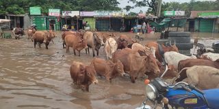
Shops left stranded in Kisumu's Ahero Town after Nyando River levee bursts
Additionally, Kisumu's wetlands are increasingly under threat as private developers encroach on the land to build modern high-rise buildings.
Encroachment into wetlands
Kisumu has several wetlands including Dunga, Ombey, Nyando, Kusa, Namutoi, Koguta, Chiga and Kisat. Wetlands are essential for flood management and prevention. However, if these areas are eroded, people will face the consequences of nature's wrath. Wetlands include bogs, swamps, peatlands, and bodies of water less than 6 meters deep.
Christopher Ola, director of freshwater systems research at the Kenya Marine and Fisheries Research Institute (KMFRI), said encroachment on wetlands threatens wetland biodiversity and increases water pollution.

Ahero Town was flooded after the Nyando River burst its banks on May 4, 2024.
Photo credit: Angeline Ochieng | Nation Media Group
Many wetlands provide wildlife habitat and fish breeding grounds. They also play an important role in filtering river water, which often carries large amounts of waste into Lake Victoria. However, as people encroach on these wetlands, they reduce the area that acts as a protective buffer or filter for the lake.
soil degradation
The growing demand for sand for construction has led to a steady increase in environmentally unfriendly activities on Lake Victoria's rivers and shores. Sand mining exposes riverbanks and riverbeds to erosion and destroys aquatic life. In Kisumu, sand mining is rampant in the Kibos and Nyamasaria rivers. This activity has also spread to several beaches around the lake.
Severe siltation of Lake Victoria also occurred due to insufficient use of agricultural land upstream. This silt was found to contribute to the growth of the nuisance water hyacinth weed and reduce the depth of the lake.
climate change
Ahero Town was flooded after the Nyando River burst its banks on May 4, 2024.
Photo credit: Angeline Ochieng | Nation Media Group
Historically, Kenya has had two major rainy seasons: the long rainy season and the short rainy season. Long rains usually occur from March to May, and short rains from October to December.
However, with global warming and rapid changes in climate, rainfall patterns have suddenly become unpredictable. For example, the short rainy season can last until January. In addition, the weather is unstable, and heavy rain can fall in a short period of time, causing flooding. Prolonged rain causes flooding, mudslides, and landslides.
lack of forest cover
Lake Victoria's water level has so far risen 14 meters. According to National Environmental Management Agency (NEMA) Kisumu County Director Leonard Ofura, one of the main reasons for the lake's flooding is excessive silt accumulation in the lake basin.
200 people evacuated due to floods in Ahero, Kisumu County
Ofrah argues that much of the soil eroded from upstream in the watershed is washed into the river and into the lake.
“You know there's a lot of agricultural activity going on around these watersheds, but there's not enough forest, so all this silt is carried into the lake by the rivers,” he says.
Ofrah suggests that the Governor's Council should take the lead in promoting soil conservation through tree planting.
“The issue of soil and water conservation is to make sure the silt is kept upstream so it doesn't run off into the lake,” he said.
Lake Victoria receives its water from several major rivers, including the Nyando, Yala, Nzoia, Miliu and Kuja rivers. The catchment areas are Nadi, Vihiga, Siaya, Kakamega, Homabay, Migori and Kisii counties.
Siaya County Meteorological Department Director Domnic Arodi explains that flooding occurs when runoff from a catchment area accumulates.
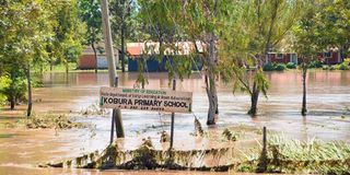
Kobura Elementary School in Ahero Town was submerged.
Photo credit: pool
For example, the Nyando River basin includes Nadi, Kericho, Muhoroni and Nyando. He argues that cultural beliefs about land ownership between communities have always prevented people from moving from their ancestral lands.
Arodi suggests that county governments begin dredging rivers that often burst their banks.
Anthropogenic activities, such as redirecting river flows for agricultural purposes, can also act as mitigation measures, he says.